EuroVelo 8 is currently planned to run some 4500 kilometres on the European mainland, from Cadiz in Spain to Athens in Greece. Our stretch is around 175 kilometres from Plan d’Orgon to Draguignan and Les Arcs. Our website digs deep to give you all the details.

Plan d'Orgon to Les Arcs
EuroVelo 8 is currently planned to run some 4500 kilometres. Overviews of the whole route can be found here and there on the internet. There is also an official site dedicated to the 850km French section on francevelotourisme.com, which has some useful details about the EV8 between Spain and Italy.
On this website, we are concentrating on around 100 kilometres of EV8 between Meyrargues and Draguignan. To this we have added two farther stretches of cycleway. In the west, we have mapped a route that enables cyclists to avoid needing to take the train to get to Meyrargues. This uses parts of the Durance à Vélo, which follows the river Durance. We re-join the EV8 in the west north of the village of Plan d’Orgon. In the east, we have added the 14 kilometre-long Vigne a Vélo. This enables cyclists to reach the railway station of Les Arcs.
Meyrargues and Les Arcs are important. Each of these towns are accessible by regional trains which allow bicycles on board without prior booking. Details about getting to our region by train and bike can be found here. Note that, in Draguignan, the EV8 continues east towards Grasse, Nice and Italy.
Our website divides the 175 kilometres from Plan d’Orgon to Les Arcs into 10 itineraries:
Plan d’Orgon to Meyrargues 60kms
4 stretches of good cycleway are connected by a mix of quiet lanes and a rough ride along a canal.
Meyrargues to Rians 20kms
This stretch involves a pleasant ride alongside an EDF canal, followed by a series of alternating stretches of main road and small side roads as the EV8 passes through the village of Jouques. From Jouques there is a quiet few kilometres on the route of the old railway line. But towards the departmental border of Var and Bouches dû Rhone, there is only the main road. At the border, the Aquaduc de Saint Bachi, is a pinch point for the EV8. Here an innovative solution needs to be found. Beyond the border, the EV8 soon reverts to the old railway route all the way into Rians.
Rians to Varages 18kms
From Rians, you are directed onto the by-pass for around a kilometre. Signage then takes you onto a back lane out of Rians, used by local residents. But after a kilometre, the old railway turns into a dirt track. Although signage takes you up a steep hill, we instead followed the route of the railway line to the village of Artigues. There, the rough track continues for another 2 kilometres, after which a newly-surfaced cycleway takes you all the way to the old station below Varages.
Varages to Barjols 6kms
The 6 kilometres from Varages to Barjols were resurfaced in 2022, and officially opened in 2025. It is in principle a great stretch. Winding through remote forest, it is already proving popular with local walkers and cyclists. However, there is a major dispute ongoing. Local residents have removed modal filters so that they can use the cycleway as a normal road with their motor vehicles. This car-centric bunch are uninsured as they merrily drive their 4×4 to the local baker to buy their baguette. But it may require a serious accident before the authorities move to re-instate the modal filters.
Barjols to Sillans-la-Cascade 17kms
The 17 kilometres from Barjols to Sillans-la-Cascade, is largely completed, though at the time of writing not yet officially opened. There are a couple of short stretches where the main road has to be used, but otherwise most of this section is on the dedicated cycleway created from the old railway line.
Sillans-la-Cascade to Salernes 9kms
Sillans-la-Cascade to Salernes, is in a “nearly open” state, and can be cycled on the old railway line until you reach the outskirts of Salernes.
Salernes to Lorgues 14kms
This 14 kilometre stretch is officially open and is a joy to ride. However some parts are shared with local motor traffic, especially in Lorgues.
Lorgues to Flayosc 9kms
Similarly Lorgues to Flayosc, 9 kilometres, is an officially opened section. This is a lovely cycleway, passing through archways and three tunnels. Signage at two of these are now meant to be car-free. However, as the official French site notes :
“Before Flayosc there’s a series of short tunnels for which you need to put on your lights. Note that you may encounter some motorised traffic coming in the opposite direction in these tunnels.”
This itinerary leads us into Draguignan. After the officially opened section ends, the EV8 takes a steep descent into the town centre on small side roads. There is a signed route involving steep climbs and decents, and our choice which is more direct, less hilly, but involves a 100 metre long footpath.
Draguignan to les Arcs 14kms
Finally, from Draguignan there is the 14 kilometre long Vigne a Vélo cycleway to Les Arcs-sur-Argens railway station.
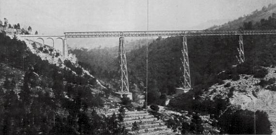
Viaduc de Siagne – (Collection G.E.C.P.)
In the near future we shall document the 58 kilometre-long stretch of EV8 to the east of Draguignan.This is partly finished, taking cyclists to the site of the old Gustav Eiffel viaduct over the river Siagne , sadly destroyed during World War 2. Across the river Siagne is the department of Alpes-Maritimes, Cannes, Nice and Italy.
Main photo by Suzanne Rushton on Unsplash